
Garmin eTrex 22x
4.3Editor score
Sunlight-readable 2.2-inch display
Preloaded TopoActive maps
GPS and GLONASS support
A handheld rugged GPS navigator with maps gives hikers, hunters, geocachers, and backcountry travelers dependable direction without requiring constant phone reception. The strongest choices combine detailed mapping, readable screens, long battery life, accurate positioning, and physical controls that remain usable in wet, cold, or dusty conditions.
We compared all ten products by examining their map options, display size, satellite support, navigation sensors, water resistance, battery claims, storage, connectivity, and intended outdoor use. The list covers traditional AA-powered eTrex devices, rechargeable models, touchscreens, compact units, and premium navigators with satellite communication.
Each numbered review explains the strongest reasons to choose that model and the compromises worth considering. The top selections cover a budget-oriented traditional navigator, a feature-rich overall option, and a premium safety-focused device. Product listings, bundles, features, and configurations can change, so confirm current details before purchasing.
4.3Editor score

3.9Editor score

4.6Editor score
As an Amazon Associate we earn from qualifying purchases.
The comparison below highlights the most important differences among these ten navigators, including display approach, mapping, positioning systems, durability, power options, and safety connectivity. It is designed to help narrow the field before considering the more detailed individual reviews.





The Garmin eTrex 22x is a compact, button-operated handheld GPS with a 4.3 rating and a clear practical purpose: provide reliable navigation for hikers, cyclists, and casual outdoor users without an oversized screen or advanced sensor package. Its sunlight-readable 2.2-inch color display presents basic mapping information in a format that remains practical in direct outdoor light, while the traditional eTrex body is easy to grip with gloves or wet hands.
We may earn a commission when you buy through this link, at no additional cost to you.
The preloaded TopoActive map includes routable roads and trails for cycling and hiking, so the device is useful straight out of the box for common navigation needs. Support for both GPS and GLONASS can improve tracking in challenging terrain compared with a GPS-only receiver, while 8 GB of internal memory and a microSD card slot provide room for additional map downloads. Its two-AA configuration offers a claimed battery life of up to 25 hours in GPS mode.
The main limitation is the modest 2.2-inch screen. Detailed topographic work can feel cramped, and the 22x lacks the three-axis compass and barometric altimeter found in the Garmin eTrex 32x. It also represents a step below touchscreen models for people who want swipe-based map exploration or larger touch targets. These compromises are reasonable for a buyer who values simplicity, compactness, and affordability over advanced navigation data.
This is an excellent choice for weekend hikers, travelers who want a secondary navigator, and anyone who prefers replaceable AA batteries over built-in rechargeable power. It is less suited to users who need precise elevation readings, a stationary heading without movement, or a large display for route planning. For those priorities, move up to the eTrex 32x or consider the Garmin eTrex Touch.
The physical-button layout reduces the learning curve and remains effective when touchscreens are less appealing in rain, cold, or heavy gloves. The receiver combines GPS and GLONASS to improve positioning options in areas where satellite visibility is less than ideal.
TopoActive maps provide a useful starting point for hiking and cycling, while internal storage and a microSD slot allow added detail when needed. The small display still demands more zooming and panning than the larger touchscreen alternatives.
We may earn a commission when you buy through this link, at no additional cost to you.
This Handheld GPS 3.2 combines a large 3.2-inch sunlight-readable screen with physical controls, making it an appealing option for hikers who want more visible map detail than a traditional compact eTrex provides. It carries a 3.9 rating and emphasizes a rugged, water-resistant design, multi-constellation positioning, and a rechargeable battery suited to extended field use.
We may earn a commission when you buy through this link, at no additional cost to you.
Its positioning system supports GPS, Galileo, BeiDou, and QZSS, with the listed position precision stated at approximately six feet. A three-axis compass supplies heading even while stationary, and a barometric altimeter adds elevation context. The IP66 rating offers protection against dust and water jets, and the rechargeable battery is advertised for up to 36 hours with convenient USB-C charging. Preloaded USA topographic maps and 32 GB of internal storage make it particularly relevant to hikers and campers within the United States.
Its trade-offs are less clearly documented than those of established Garmin models. The 3.9 rating is respectable but trails the strongest products in this list, and buyers should consider the long-term availability of map updates, app compatibility, support resources, and accessory choices. The specification also uses the broader water-resistant term without the benefit of a clearly stated extreme waterproofing standard comparable to IPX7 or IP67.
Choose this model if you specifically want a large screen, physical buttons, broad GNSS support, and USB-C charging in a compact body. It is a strong match for domestic hiking and camping, especially for users who find 2.2-inch screens difficult to read. Those who prioritize a mature ecosystem, extensive documentation, and smooth integration with established outdoor apps may feel more confident with a Garmin model.
The 3.2-inch color display offers a noticeably larger canvas for topographic detail, waypoints, and route review. Physical buttons preserve tactile operation in poor weather, so the device does not force a choice between readability and glove-friendly control.
A three-axis compass is useful when the user wants a bearing without first moving, while the barometric altimeter provides elevation information. These sensors make the navigator more versatile than a basic route-following unit.
We may earn a commission when you buy through this link, at no additional cost to you.
The Garmin eTrex 32x builds on the simpler eTrex 22x by adding a three-axis compass and barometric altimeter, making it the stronger traditional option for users who want more navigation context. It has a 4.2 rating, a rugged handheld form, and a 2.2-inch sunlight-readable color display designed for clear route information rather than expansive visual exploration.
We may earn a commission when you buy through this link, at no additional cost to you.
TopoActive maps arrive preloaded with roads and trails suited to hiking and cycling. GPS and GLONASS support improve positioning options in challenging environments, and the 8 GB of internal memory can be supplemented through the microSD card slot. Most importantly for navigation, the three-axis compass can show heading while stationary, while the barometric altimeter supplies elevation data that can be useful around steep routes and changing terrain.
The screen remains small, so planning intricate routes or examining many nearby points of interest takes more effort than on a 3-inch or 5-inch touchscreen. There is also no multi-band positioning or built-in satellite communications, and the 25-hour GPS-mode claim is less generous than the extended expedition figures associated with some newer alternatives. AA batteries are easy to find but must be carried as consumables on remote trips.
The eTrex 32x is well suited to hikers, hunters, geocachers, and users who want a stationary compass without moving into a smartphone ecosystem. It is also a logical step up from the 22x for anyone specifically seeking elevation data. For a larger screen, touch controls, advanced accuracy, or emergency communication, compare the eTrex Touch, Montana 710, and GPSMAP 67i.
The electronic compass provides a heading while the user remains still, and the barometric altimeter adds elevation context. Together, they make the eTrex 32x more useful for terrain awareness than basic route-only devices.
The compact body, physical controls, and replaceable batteries create a straightforward field experience. Its size also makes it less cumbersome to carry than the larger Montana models for activities where screen space is not essential.
We may earn a commission when you buy through this link, at no additional cost to you.
The Garmin eTrex Touch is the most complete traditional-category navigator in this roundup, combining a responsive 3-inch color touchscreen, multi-band GPS, detailed topographic mapping, and exceptional stated battery endurance. Its 3.9 rating does not lead the field, but the underlying feature set makes it the most persuasive overall choice for buyers who want modern navigation without carrying a full-size outdoor computer.
We may earn a commission when you buy through this link, at no additional cost to you.
The screen supports swiping and zooming through detailed roads and trails, terrain contours, elevations, summits, parks, coastlines, rivers, lakes, and numerous points of interest. Multi-band GPS is designed to improve positional accuracy, while the rechargeable battery is claimed at up to 130 hours in all-satellite systems plus multi-band mode and up to 650 hours in expedition mode. Its IP67 rating handles weather and rugged conditions, and the included Spine Mount 2 supports an accessory-oriented setup.
Some capabilities extend beyond what the included map package provides. Ongoing access to premium content requires a separately sold Outdoor Maps+ plan, and compatible accessories also cost extra. The device's 3.9 rating may give cautious buyers pause, especially when compared with older Garmin models that have established feedback, but ratings alone do not measure map quality, accuracy, or field suitability. The touchscreen can also be less desirable for users who strongly prefer physical buttons.
This is the best overall recommendation for a modern handheld GPS with maps. It is especially attractive to hikers, backcountry travelers, and geocachers who value accurate positioning, detailed maps, smartphone planning integration, and long battery life. A buyer who primarily wants the lowest-cost reliable navigator should consider the eTrex 22x, while anyone requiring satellite SOS should examine the GPSMAP 67i.
A 3-inch high-resolution color display offers enough room to inspect routes and topographic features while retaining a relatively compact body. Swipe and zoom interactions provide a more natural way to explore maps than the limited interface of older eTrex models.
Multi-band support is intended to provide stronger positional accuracy in difficult terrain. The long expedition-mode figure makes the Touch appealing for extended trips, while the standard USB-C charging system simplifies routine power management.
Garmin Explore compatibility allows compatible phones or tablets to be used for trip planning, activity review, and management of waypoints and courses. The workflow is useful for users who research routes at home but want dedicated hardware in the field.
We may earn a commission when you buy through this link, at no additional cost to you.
The S190 Handheld GPS is a large-screen hiking navigator with a perfect 5.0 rating, broad satellite support, and a generous 64 GB of storage. Its 3.2-inch sunlight-readable color display and worldwide basemap make it a potentially strong fit for campers and hikers who want more visible mapping information without moving to a full-size Garmin touchscreen.
We may earn a commission when you buy through this link, at no additional cost to you.
The receiver connects with GPS, BeiDou, Galileo, and QZSS, while a three-axis compass shows heading when the user is stationary. It records routes and can guide the user back along the same path, which is useful for exploring unfamiliar terrain. Preloaded USA topographic maps and a worldwide basemap support hiking and camping, and the rechargeable battery is stated to last up to 36 hours. Its IP64 rating provides protection against splashes and outdoor exposure.
The most important caveat is map detail. The supplied information warns that the map can become blank when zoomed in beyond the limited zoom tier downloaded for the user's state. Full-detail map files are available through the manufacturer's website, with instructions in the product video and user manual. That arrangement may suit a buyer comfortable with a separate download process, but it is less convenient than a device with detailed regional maps already installed.
The S190 is best for hikers who prioritize screen size, route recording, and internal storage and who are prepared to manage additional map downloads. Its perfect rating is encouraging, although a small review history or limited brand familiarity can still justify careful research. Users who need a highly mature support system or deeply detailed maps out of the box may prefer the Garmin eTrex Touch.
The ability to record an exact route and navigate back along it turns the device from a passive map viewer into a practical exploration tool. The stationary compass also helps orient the user before movement begins.
A 64 GB internal storage allowance provides room for downloaded map files. The important distinction is that storage alone does not solve regional detail; buyers should understand the supplied state-level map limitations before relying on close-range navigation.
We may earn a commission when you buy through this link, at no additional cost to you.
The Garmin eTrex 10 remains a straightforward option for travelers who want a rugged global navigator without a large touchscreen. It carries a 4.3 rating and centers on essential functions: a worldwide basemap, a compact monochrome display, dependable positioning, paperless geocaching, and replaceable batteries.
We may earn a commission when you buy through this link, at no additional cost to you.
The 2.2-inch monochrome screen is easy to read in sunlight and helps conserve power compared with a color display. A WAAS-enabled GPS receiver with HotFix and GLONASS support is designed for fast positioning and a reliable signal. The preloaded worldwide basemap makes the eTrex 10 particularly useful for international travel, while the IPX7 waterproof rating protects it from rain and splashes.
Paperless geocaching and Garmin spine mounting support add flexibility for users with established Garmin accessories. On the other hand, the device does not offer the same topographic richness, color cues, sensors, or touchscreen convenience as newer models. Its claimed battery life of up to 20 hours is shorter than that of the Garmin eTrex 22x and 32x, and the monochrome display can make detailed terrain interpretation less immediate.
The eTrex 10 is best for international travelers, occasional hikers, and buyers who value simplicity. It can serve as a useful backup device that offers broad location awareness without demanding extensive menu navigation. For detailed trail maps, a color display, electronic compass, or barometric altimeter, choose one of the newer eTrex models instead.
A preloaded worldwide basemap reduces the need to manage regional map installations during international travel. The monochrome display focuses attention on routes and locations without the glare and power demands associated with color screens.
IPX7 protection handles wet conditions, while paperless geocaching support serves a dedicated field activity. These are modest but meaningful advantages for users who prefer the long-established Garmin eTrex format.
We may earn a commission when you buy through this link, at no additional cost to you.
The Garmin Montana 710 is a large-screen handheld GPS built for people who want detailed cartography and vehicle-to-trail flexibility. Its 5-inch glove-friendly color touchscreen, 4.3 rating, and extensive map and sensor features distinguish it from the compact eTrex line without adding satellite communication.
We may earn a commission when you buy through this link, at no additional cost to you.
TopoActive maps are included, while additional street and water mapping can be downloaded separately. High-resolution satellite imagery offers a photorealistic overhead perspective and helps users create waypoints around visible landmarks. The 32 GB internal storage provides room for maps and other content, and the rugged construction is rated to MIL-STD-810 for thermal, shock, and vibration conditions as well as IPX7 for water resistance.
Built-in ABC sensors add an altimeter, barometer, and three-axis electronic compass, while Garmin Explore and Garmin Connect compatibility supports planning, trip review, and active weather forecasts. The rechargeable battery is listed for up to 24 hours in GPS mode and up to 432 hours in expedition mode, with AA battery capability as another option. Premium mapping content requires a separate Outdoor Maps+ subscription, and mounting accessories are also sold separately.
The 5-inch display is the principal benefit and the principal bulk issue. It is excellent for overview route planning, teaching, navigating with a vehicle mount, or reviewing satellite imagery, but it may feel unnecessarily large for a fast hiker. Choose the Montana 710 when screen space and versatile mapping matter more than minimum weight. The eTrex Touch is the more compact alternative, while the Montana 700i adds satellite communication.
The 5-inch display makes terrain contours, satellite imagery, route alternatives, and surrounding landmarks easier to interpret. A glove-friendly touchscreen improves usability when cold weather or active movement would make a small target difficult to use.
The Montana 710 can serve in hiking, paddling, driving, and mounted-navigation scenarios. MIL-STD-810 and IPX7 ratings reinforce its suitability for demanding outdoor environments and travel in poor weather.
Recharge and AA battery options provide more than one way to manage power. The altimeter, barometer, and compass add practical terrain and weather context without moving to a smartphone.
We may earn a commission when you buy through this link, at no additional cost to you.
The Garmin eTrex SE is a compelling middle ground between an uncomplicated physical-button navigator and a connected modern device. It carries a 4.2 rating, a sunlight-readable 2.2-inch display, multi-GNSS support, and a digital compass, while its extremely long stated battery figures make it particularly interesting for expedition-style travel.
We may earn a commission when you buy through this link, at no additional cost to you.
Pairing with the Garmin Explore app on a compatible smartphone enables wireless software updates, trip planning, Active Weather, smart notifications, and additional mapping. Automatic Geocaching Live updates can bring descriptions, logs, and hints to the device. Navigation support includes GPS, GLONASS, Galileo, BeiDou, and QZSS, giving the receiver access to multiple global satellite systems in challenging environments.
The biggest strength is endurance: the device is listed for up to 168 hours in standard mode and up to 1,800 hours in expedition mode using replaceable AA batteries. Its IPX7 water rating supports use in wet weather. The trade-off is that the 2.2-inch screen remains modest, and unlike some current eTrex models, the supplied specification does not identify an integrated three-axis compass or barometric altimeter.
The eTrex SE is ideal for long-distance hikers, expedition users, and geocachers who want extensive phone integration without giving up physical controls. It may also be a good fit for travelers who prefer carrying AA batteries rather than managing a proprietary rechargeable pack. Those wanting a larger touchscreen, stationary compass, barometer, or emergency satellite functions should look toward the eTrex Touch or GPSMAP 67i.
The stated 1,800-hour expedition figure dramatically reduces charging concerns on remote journeys. Replaceable AA batteries also offer a practical fallback when carrying a specialized charging cable would be inconvenient.
The Garmin Explore connection improves planning and trip review without turning the handheld into a phone-dependent device. Geocaching Live updates are particularly relevant for users who want current cache information at the trailhead.
We may earn a commission when you buy through this link, at no additional cost to you.
The Garmin GPSMAP 67i is the strongest safety-focused navigator in this roundup, combining conventional topographic navigation with two-way satellite messaging and interactive emergency SOS. Its 4.6 rating is the second-highest among the reviewed products, and the feature set justifies serious consideration for travelers who venture beyond reliable cellular coverage.
We may earn a commission when you buy through this link, at no additional cost to you.
The 3-inch sunlight-readable color display keeps maps readable in the field, while multi-band GNSS support is intended to improve positional accuracy. Preloaded TopoActive maps cover familiar outdoor navigation, and satellite imagery can provide another orientation layer. When paired with a compatible smartphone, the device can also provide active weather forecasts and Geocaching Live information through Garmin's broader ecosystem.
Its defining feature is the Iridium satellite network. Users can send and receive messages, share location, and trigger an interactive SOS coordinated by a staffed emergency response center. Those services require an active subscription, and regulations in some jurisdictions may restrict satellite communication devices. Because this listing is renewed, buyers should also examine condition details, warranty coverage, and included accessories carefully.
The GPSMAP 67i is the best premium choice for hikers, guides, overlanders, and expedition travelers who prioritize emergency communication. It is less necessary for day hikes in familiar areas, and the ongoing service requirement makes it more complex than a standard handheld GPS. Buyers who want satellite capability but prefer a much larger screen can also consider the Garmin Montana 700i.
Interactive SOS and two-way messaging can provide a critical communication path in areas without cellular service. The functions are designed for emergencies and check-ins, though an active satellite subscription and local regulations apply.
This is not simply a communicator attached to a basic navigator. Multi-band GNSS, TopoActive maps, satellite imagery, and smartphone weather access make it a capable standalone field device.
The internal rechargeable battery is listed for up to 165 hours in 10-minute tracking mode and up to 425 hours in expedition mode with 30-minute tracking intervals. These figures are particularly relevant when the device may be used far from charging opportunities.
We may earn a commission when you buy through this link, at no additional cost to you.
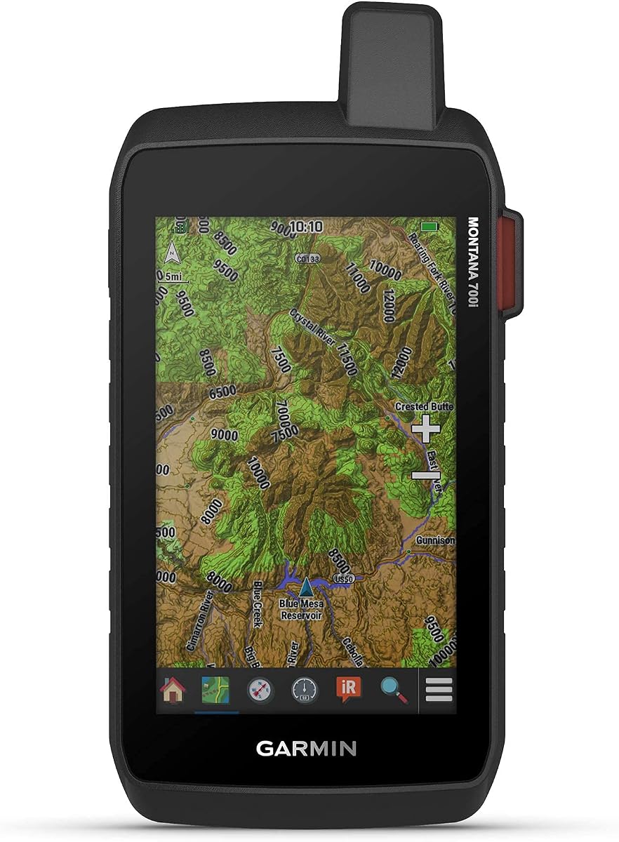
The Garmin Montana 700i combines a large 5-inch glove-friendly touchscreen with built-in inReach satellite technology, making it a capable choice for travelers who want both visual navigation comfort and emergency communication. Its 4.0 rating reflects a capable but not universally favored product, and the renewed designation calls for attention to condition and warranty details.
We may earn a commission when you buy through this link, at no additional cost to you.
Rugged military-grade construction supports demanding outdoor use, while the large display makes topographic maps, routes, and satellite-oriented functions easier to review. Preloaded TopoActive maps and City Navigator street mapping cover both trail and road environments. A three-axis compass and barometric altimeter add navigation sensors, and the device supports GPS and Galileo positioning.
The built-in inReach functions include interactive SOS through a 24/7 monitoring center and two-way messaging over the global Iridium satellite network. An active satellite subscription is required, and some jurisdictions regulate or prohibit satellite communications equipment. ANT+, Wi-Fi, and Bluetooth connectivity broaden the device's features through location sharing, BirdsEye Satellite Imagery downloads, and Connect IQ support, while Garmin Explore compatibility assists with planning and review.
The Montana 700i is best for people who prioritize a large touchscreen and satellite safety functions in one device. It may be excessive for local day hikes, where a smaller eTrex is easier to carry, and its renewed status makes careful condition assessment important. Compared with the GPSMAP 67i, it offers more display space but a less advanced stated GNSS configuration, making the choice primarily one between screen size and compactness.
The 5-inch glove-friendly touchscreen offers a generous view of topographic routes, street navigation, and surrounding features. It is especially useful for users who share a route with a group, inspect satellite imagery, or navigate from a mounted position.
Interactive SOS and two-way satellite messaging extend the device beyond ordinary cellular coverage. Wi-Fi, Bluetooth, and ANT+ support add useful wireless functions, while the required subscription should be considered before the device is put into remote service.
We may earn a commission when you buy through this link, at no additional cost to you.
The most suitable handheld rugged GPS navigator with maps depends on the terrain, route complexity, emergency requirements, and preferred operating style. Use the following factors to compare screen size, navigation capability, endurance, mapping, and physical design before making a final decision.
Choose a compact physical-button model for fast hiking and a larger touchscreen for complex route review.
Verify regional coverage, download requirements, storage, and extra-content costs before buying.
Favor multi-GNSS or multi-band models for remote and complex terrain.
Choose a compass and altimeter for stationary headings and elevation-aware route planning.
Compare normal and expedition runtimes, then choose replaceable or rechargeable power appropriately.
Compare exact IP ratings and construction standards, then match protection to expected conditions.
Include subscriptions, accessory needs, and legal restrictions in the final feature comparison.
Match device size to activity, carrying comfort, and mounting needs rather than screen size alone.
Before the first trip, power the navigator fully, set the correct date and time, confirm that the regional maps are present, and review the interface. If the device supports phone or web connectivity, use the appropriate Garmin service to download maps, create routes, transfer waypoints, and check for software updates. Do this at home or another dependable location with power and connectivity. It is also wise to save an overview of the planned route, identify key waypoints, and check how the compass, altimeter, backtracking, and expedition settings operate.
In the field, treat the navigator as one part of a complete navigation plan. Carry a paper map and compass when appropriate, keep spare batteries or a charging cable for the selected power strategy, and monitor the battery rather than assuming the maximum runtime will be reached in every condition. Pause periodically to confirm that the displayed position, direction of travel, route line, elevation, and nearby landmarks agree. The electronic compass can be affected by nearby metal or magnetic objects, and a digital position should never replace observation of the surrounding terrain.
After the trip, remove any residual moisture, clean the screen gently, and keep the charging or battery compartment dry. Follow the manufacturer's guidance for storage temperature and charging, especially for lithium-ion devices. Download the latest maps and software periodically, and preserve account information, subscriptions, routes, and waypoints with a backup. If the device is used around salt water, mud, or fine dust, rinsing or careful cleaning according to the manual can help prevent contamination of ports and controls.
A dedicated handheld GPS generally offers longer battery life, physical controls, stronger outdoor positioning features, and better operation in cold or wet conditions. It can also continue providing navigation in areas without cellular service. Smartphones add convenience, app flexibility, and easy route sharing, but require more care to keep charged and may be less rugged. The best choice depends on the trip, but dedicated hardware is usually more dependable for remote navigation.
It can be valuable in mountains, forests, and other areas where the sky view is partially obstructed. Multi-GNSS combines satellite systems from different regions, while multi-band positioning is designed to improve accuracy by using multiple frequencies. The improvement is most useful on demanding routes. It does not remove the need for careful route planning, situational awareness, or a backup navigation method.
A compass provides a heading even when stationary and is helpful for orienting yourself or checking a route. A barometric altimeter gives elevation information and can help track climbs or descents. They are not essential for every casual walk, but they add value for hikers following contour lines, traveling in steep terrain, navigating in poor visibility, or using a dedicated compass as a backup.
Reliability matters more than any isolated specification. A good navigator should have appropriate maps, a readable display, dependable positioning, sufficient battery life, and controls that work in the expected conditions. Water resistance and durable construction matter, but they should complement rather than replace usable navigation. Emergency communication is also important for genuinely remote travel.
Many are water-resistant rather than completely waterproof, and the specific rating matters. IPX7, IP66, IP67, and IP64 each describe different exposure protections. A device can handle rain while still being vulnerable to submersion, high-pressure water, or charging with a wet port. Review the exact rating and avoid operating or charging the unit under conditions outside its specified limits.
The GPSMAP 67i and Montana 700i rely on an active satellite subscription for their listed inReach messaging and interactive emergency functions. Plans and service terms may affect available features. Buyers should also check whether satellite communication devices are permitted in their destination and whether local restrictions apply. Emergency support remains subject to the provider's service terms and availability.
AA batteries are convenient for trips where replacement cells are easy to carry and provide a straightforward fallback when a charging cable is unavailable. Rechargeable devices are more convenient for regular use, particularly when they include USB-C charging and advanced battery modes. Compare the actual expected runtime, battery management, and expedition claims rather than relying on one headline duration figure.
They should not be the sole navigation resource on a remote trip. Electronics can lose power, become damaged, experience firmware problems, or show a position that is difficult to interpret. Carrying a paper map, compass, and relevant emergency equipment adds redundancy. A navigator is best treated as a powerful tool within a broader plan that also includes route research, communication options, and sound decision-making.
The Garmin eTrex 22x is the strongest budget-oriented choice for straightforward hiking and cycling, offering a compact body, sunlight-readable color screen, preloaded TopoActive maps, and familiar physical controls. The Garmin eTrex Touch is the most complete overall option because it combines multi-band positioning, detailed mapping, a modern touchscreen, Garmin Explore integration, and exceptional stated endurance. The Garmin GPSMAP 67i stands apart as the best premium safety pick, adding two-way satellite messaging and interactive emergency SOS.
Other buyers may find better alignment in the Garmin eTrex 32x for traditional sensors, the 3.2-inch Handheld GPS for physical buttons and a larger display, or the Montana 710 for extensive mapping on a 5-inch screen. The Montana 700i combines that large-screen experience with satellite communication, while the eTrex SE offers connected planning and extraordinary expedition-mode battery claims. Prioritize the maps, positioning, sensor package, power method, and environment that match your actual trip rather than choosing solely by screen size.
Product availability, map offerings, bundles, subscriptions, and current configurations can change, so review the latest listing and manufacturer documentation before purchasing. Confirm that the intended region is covered, check which accessories are included, and understand any separate premium-service requirements. With those details verified, the right handheld rugged GPS navigator with maps becomes a dependable tool for safer and more confident exploration.